 |
| Sunrise at Three Houses |
I lean against the car, stretching my legs. It's just after 6am and the sun's first glow is starting to show on the distant horizon in spectacular fashion. I'm at Three Houses, at the beginning of Stage 5 of the Great Train Run, waiting for the runners who have done the first half to arrive. It's the second year of the run, inspired by the Great Train Hike and run on the same day.
Every year the Barbados National Trust organises the Colin Hudson Great Train Hike. Started in 2003 the hike goes along the route of the long defunct Barbados railway. The Barbados railway traversed from Bridgetown to Belleplaine on the North east coast, some 26 miles. It began in 1881 and ran until 1937, when a lack of maintenance and falling demand led to its closure. No set of black and whites of old Barbados is complete without a picture or two of the railroad and it's stations.

Even in a island as flat as Barbados, building a railway was a challenge. It wound its way out of town through Welches, up through Salters, past the then major sugar factories at Bulkeley and Carrington out to Bushy Park and Three Houses where it began the downward slope to the East coast. If you look carefully, you can still see the route today on a map, crossing Barbados. Although all remnants of the actual metal tracks are long gone, tell tale cart roads across the southern section of Barbados clearly indicate the route.
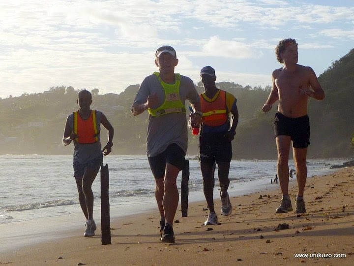
Last year Ralf, No.1 FRB with the Hash House Harriers, avid runner and veteran of many marathons, thought he would run the route. A shade under a marathon length, it is a real cross country trek, mostly cart roads in the first half and then coastal paths and even a section of sea in the second. In true style, Ralf planned it down to a T, dividing it up into stages and putting down target times for each.
The sun is up and running by the time Lydia, Ralf's wife arrives with two friends - the support group. "They'll be here in 10 minutes!" she says. I do my final stretches, trying to warm up my still sleeping muscles. Ralf, accompanied by Andre Procope and Winston Mascoll of Ufukozu won't tarry long at this stop, just long enough for a quick drink, then we'll be on the way again. They arrive looking no worse for wear having done 22km of off-road trails. The second half is only 18km, but the trail will be even more challenging.
We head off towards Fortesque, a high plateau overlooking the rough east coast. The train route is fully obscured in this section, housing developments have taken care of that. The stony cart roads give way to knee high grass as we make our way parallel to the cliff face. Hard as it is, I can only imagine what it must be like for legs that have already done 22km.
 |
| Section of Consett Trail |
At Fortesque we begin the descent through the Consett Cutting, a 'cut' through coral rock that enabled the train to get down to sea level and continue up the coast. The Cutting is a quiet, leaf covered trail, walls of coral alternate with sea grape, glimpses of the sea in-between. The Cutting was famous as the steepest section of track on the return route. There are stories of carriages breaking away down the slope and resulting deaths, of the train literally unable to make the grade - with the consequence of the third class passengers having to get off and push, watched by the second class passengers, who also got off, but were only required to walk alongside, while first class was never disturbed...
We get down to Consett bay, well-used by fishermen from the area, and with as many wrecked boats as they are seaworthy ones scattered around the hauling area. The trail north of Consett is now fully eroded, and the coastal land is impassable - so it's onto to the slippery rocks and into the sea we go, hoping our shoes we stay on as they suck up sand and grit. As we wend our way north, the coral foundations of railway bridges dot the route, many of them fallen into the sea, victims of land and sea erosion. These were impressive structures, and must have always been a nightmare for maintenance. On the sea side, lengths of train track stick up from the sand, jagged, rusty - the remnants of a rudimentary sea defence to hold off the rough east coast seas.
 |
| Coming up from Consett into Bath, the sun behind us. Jagged remnants of the track stick up out of the sand. |
We finally round the last headland and are in view of Bath, the end of stage 5. The support group is waiting with encouraging words as we scrunch along the beach, sand and water sloshing in our shoes, and a short run onto to the Bath Beach Facility where we have the opportunity to take them off and wash out the sand.
 |
| Entering Martins Bay |
Moving on from Bath, we run past the Bath Waterfall and onto the coastal trail that will take us up to Martins Bay. Between sea erosion and uncontrolled land drainage, the path is considerably eroded since last year, leaving us to negotiate narrow strips of coral sloping steeply down to the sea. We run, ducking under tunnels through clumps of Screw pine (pandanus), the ground littered with slippery dry leaves, numerous streams and broken rail bridges and into Martins Bay. A quick stop for a drink and then back on the trail to Tent Bay and Bathsheba.
It's still early morning in Bathsheba, and the place is empty, save for a full house at St.Aidans Church. We head on to Joe's river, passing under the now derelict railway bridge below Edgewater Hotel, and on to the beach at Cattlewash. Here we rejoin the coast road which runs inland of the sand dunes for 5.2km up to the end of the route at Belleplaine.
 |
| The last lap up cattlewash, 5.2km of hot sun (2010) |
This is the hardest section for sure, the sun by now well up and beating down on our backs, running into the wind. The long highway seems endless and even the scenic foothills under Chalky Mount fail to motivate. Eventually Barclay Park edges into view and then with it behind us, the final tramp into Belleplaine to the end of the line and a cold beer, well deserved.

And this is the route. Thanks to Ralf for the run and Lidia for the support. Running photos courtesy ufukuzo.com which also has more information about the run on its facebook page.


Thanks Vaughn. I am hoping you'll run the entire route with me one day.
ReplyDeleteid love to come along too!
ReplyDelete